brown branch stem coated in ice melting
Ice accretion of 0.25-0.50 of an inch can weigh down power lines and snap tree limbs, triggering power outages; photo by Pixabay on Pexels.com

Parade of winter storms will bring snow, ice and hazardous travel conditions from the Midwest to the Northeast

February 5, 2025

AccuWeather Global Weather Center – Feb. 5, 2025 – A series of back-to-back winter storms will slam parts of the Midwest, Northeast and mid-Atlantic with slippery and dangerous travel conditions through the middle of next week.

AccuWeather forecast map showing a large storm expected from Wednesday to Thursday. The map displays precipitation types across North America. A low-pressure system marked with a red 'L' is centered near Kansas City, with red arrows indicating its projected movement eastward. The storm system brings different weather conditions: green areas in the southern U.S. (including Springfield, Knoxville, and Washington) indicate rain and thunderstorms. A broad pink band stretches from Minneapolis and Chicago through Pittsburgh, New York, and Boston, representing a mix of rain, ice, and snow. Northern regions, including parts of Canada (Thunder Bay, Sudbury, Moose Factory) and the northeastern U.S., are shaded blue, indicating heavy snowfall. The timestamp in the bottom right reads 08:56Z, February 5, 2025

“February is kicking off with a very stormy pattern. A parade of three winter storms will bring snow, ice and sleet to millions of people from the Midwest through the Northeast,” AccuWeather Chief On-Air Meteorologist Bernie Rayno said. “Travel will be treacherous on roads and highways along the path of this storm. People should be prepared for power outages in areas where ice accumulates on tree branches and power lines.”

Snow, sleet, ice and freezing rain from the midweek winter storm and the weekend winter storm could affect more than 128 million people across 24 states.

Midweek ice storm impacts

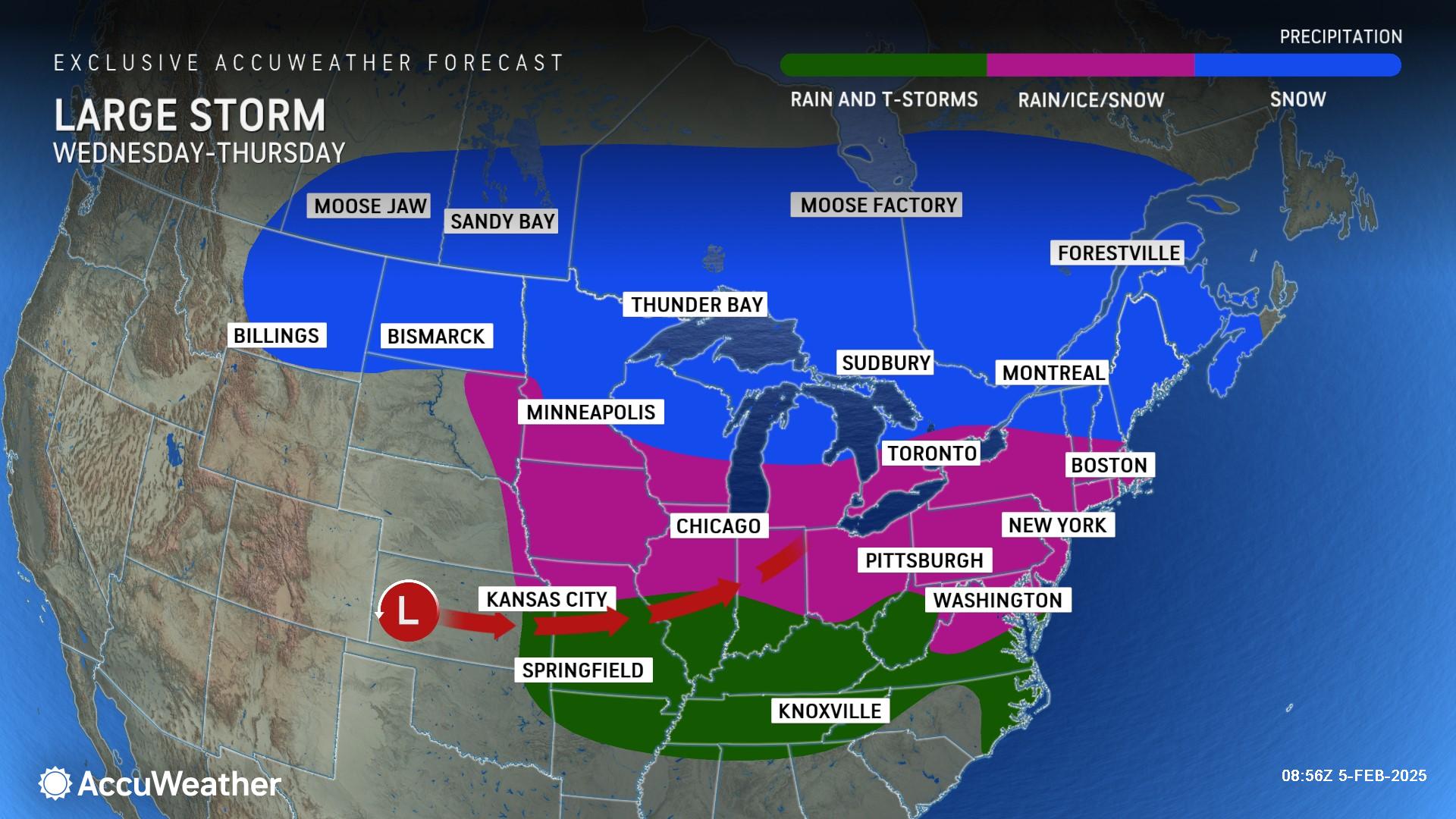
AccuWeather expert meteorologists say a large winter storm will bring snow, sleet and significant icing as it races from the Plains into the Northeast and mid-Atlantic through Thursday.

Midweek Ice Storm

AccuWeather forecast map highlighting the impact of a dangerous ice storm expected to last into Thursday. A wide swath of pink shading stretches from St. Joseph and Des Moines in the Midwest through Peoria, Chicago, Indianapolis, Detroit, Pittsburgh, and Toronto, extending eastward into New York, Albany, and Boston. Darker pink regions indicate areas with more severe ice accumulation, particularly around Pittsburgh and Washington, D.C. The map includes warnings for slippery travel, tree damage, and power outages. A color bar at the top categorizes the impacts from localized to severe. Timestamp in the bottom right reads 15:05Z, February 5, 2025.

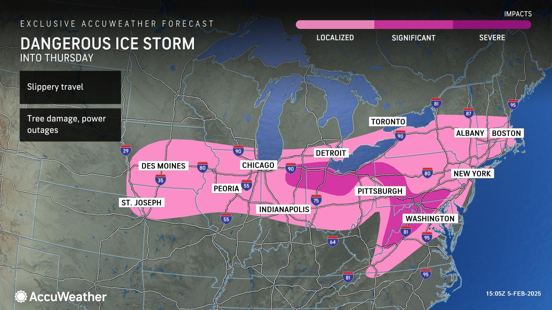
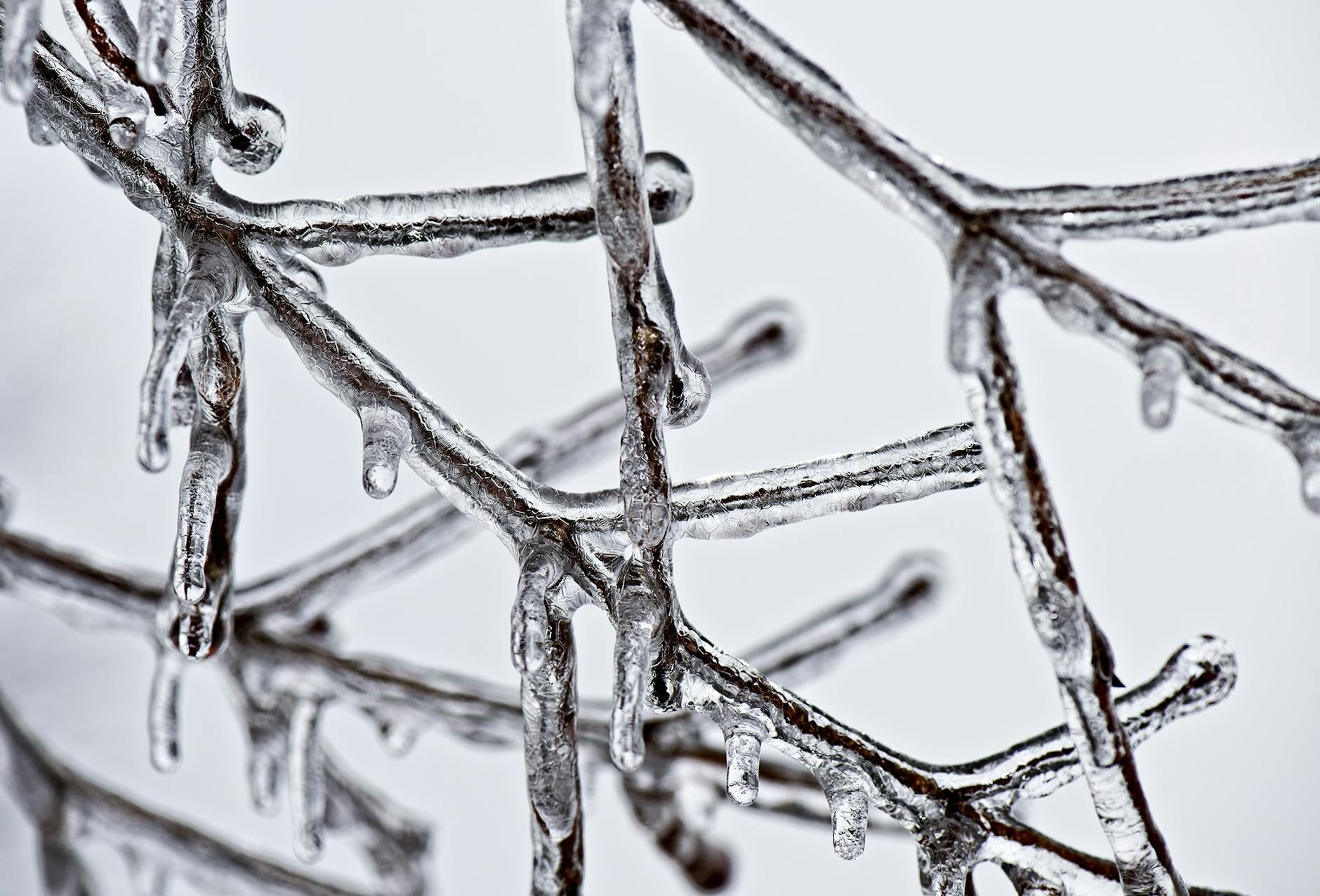
A corridor of ice is expected along the path of the storm where warm and humid air from the South clashes with cold Arctic air from the North.

“Freezing rain is the most dangerous precipitation for travel, there is no traction at all on it,” said AccuWeather Senior Meteorologist Marshall Moss. “Ice patches are clear, making it tough for drivers to tell if roads are icy or just wet. Ice accumulations can weigh down tree branches and power lines, resulting in power outages.”

Regional power outages are possible in parts of southwestern Pennsylvania, western Maryland, eastern and northern West Virginia, as well as parts of northern Virginia.

Midweek Power Risk

AccuWeather forecast map highlighting power outage risks into Thursday. The map shows a wide yellow-shaded region stretching from Des Moines and Peoria through Chicago, Indianapolis, Detroit, Columbus, Erie, Scranton, and Albany, indicating areas at risk for localized outages. A darker orange region centered around Washington, D.C., and parts of West Virginia and Virginia suggests a higher risk of more widespread outages. A color bar at the top classifies the outage risk from localized (yellow) to widespread (red). Timestamp in the bottom right reads 16:42Z, February 5, 2025.

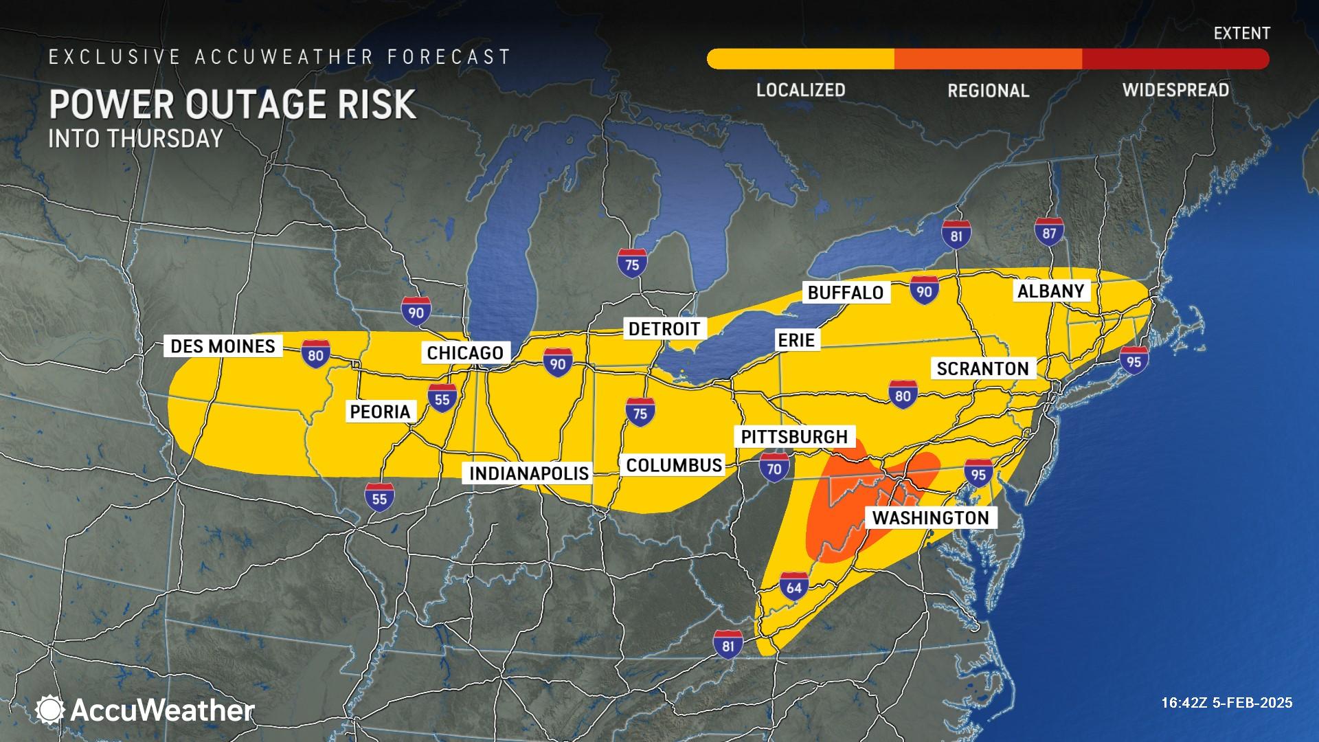
A significant risk of icing will stretch from northeastern Indiana through southern Michigan and northern Ohio to much of Pennsylvania and Maryland, eastern West Virginia, and western Maryland.

“A storm sweeping across the central and eastern United States will bring a swath of hazardous freezing rain through Thursday. Major metropolitan areas which are expected to experience at least a glaze of ice, include, Chicago, Detroit and Cleveland,” warned AccuWeather Meteorologist Brandon Buckingham.

The core of ice impacts is expected to develop overnight Wednesday into Thursday morning, spelling trouble for morning commuters along heavily traveled corridors including interstates 76, 80, 81 and 90.

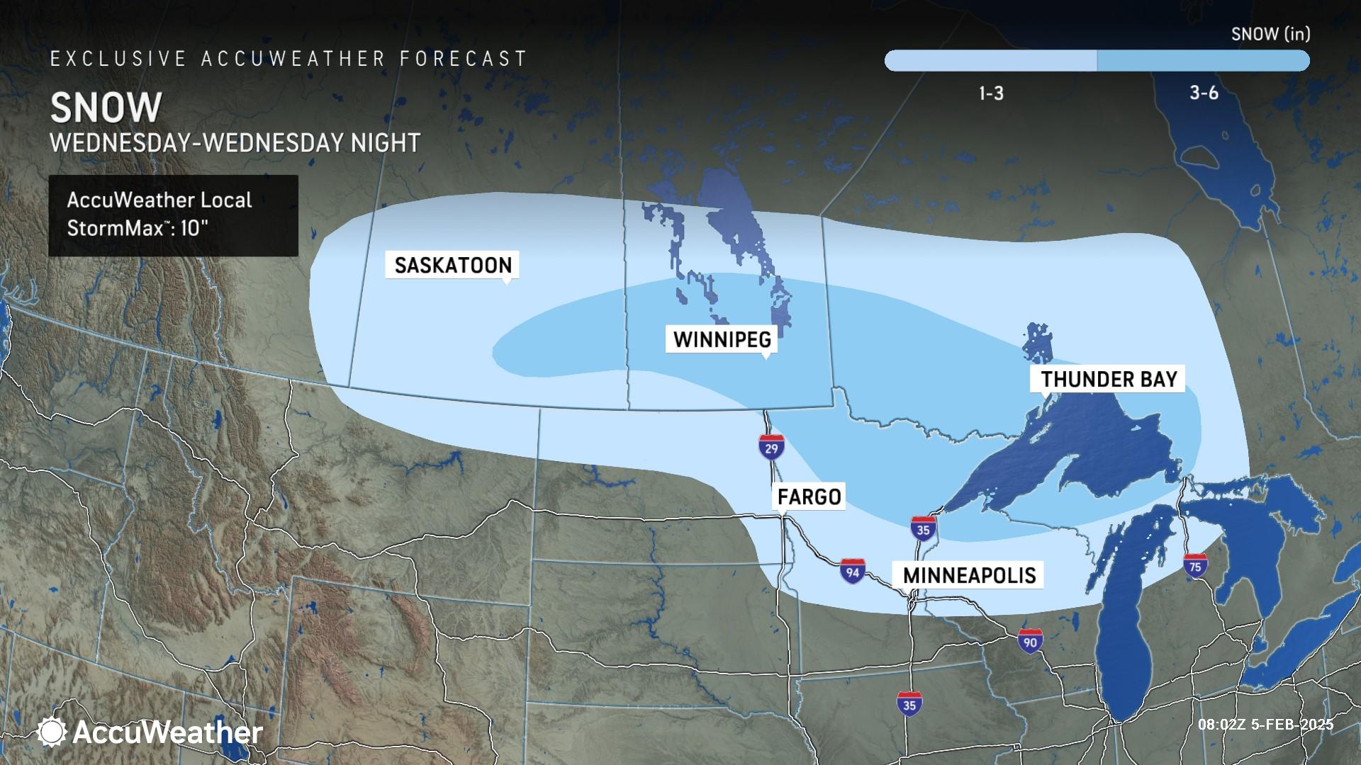
Snow accumulations of 1-3 inches are forecast from northeastern Montana through northern Michigan through Wednesday night. An area of 3-6 inches of snowfall is expected across northern Minnesota through the Upper Peninsula of Michigan. The AccuWeather Local StormMax™ across the region is 10 inches.

Midweek Snow — Central

AccuWeather forecast map showing expected snowfall from Wednesday into Wednesday night. A large area of light blue shading extends from Saskatoon in Canada through Winnipeg, Fargo, Minneapolis, and Thunder Bay, indicating snowfall accumulation. Darker blue areas suggest higher totals. The snowfall key at the top indicates expected amounts, ranging from 1-3 inches (light blue) to 3-6 inches (darker blue). A black text box in the top left notes that the AccuWeather Local StormMax™ could reach 10 inches. Timestamp in the bottom right reads 08:02Z, February 5, 2025."

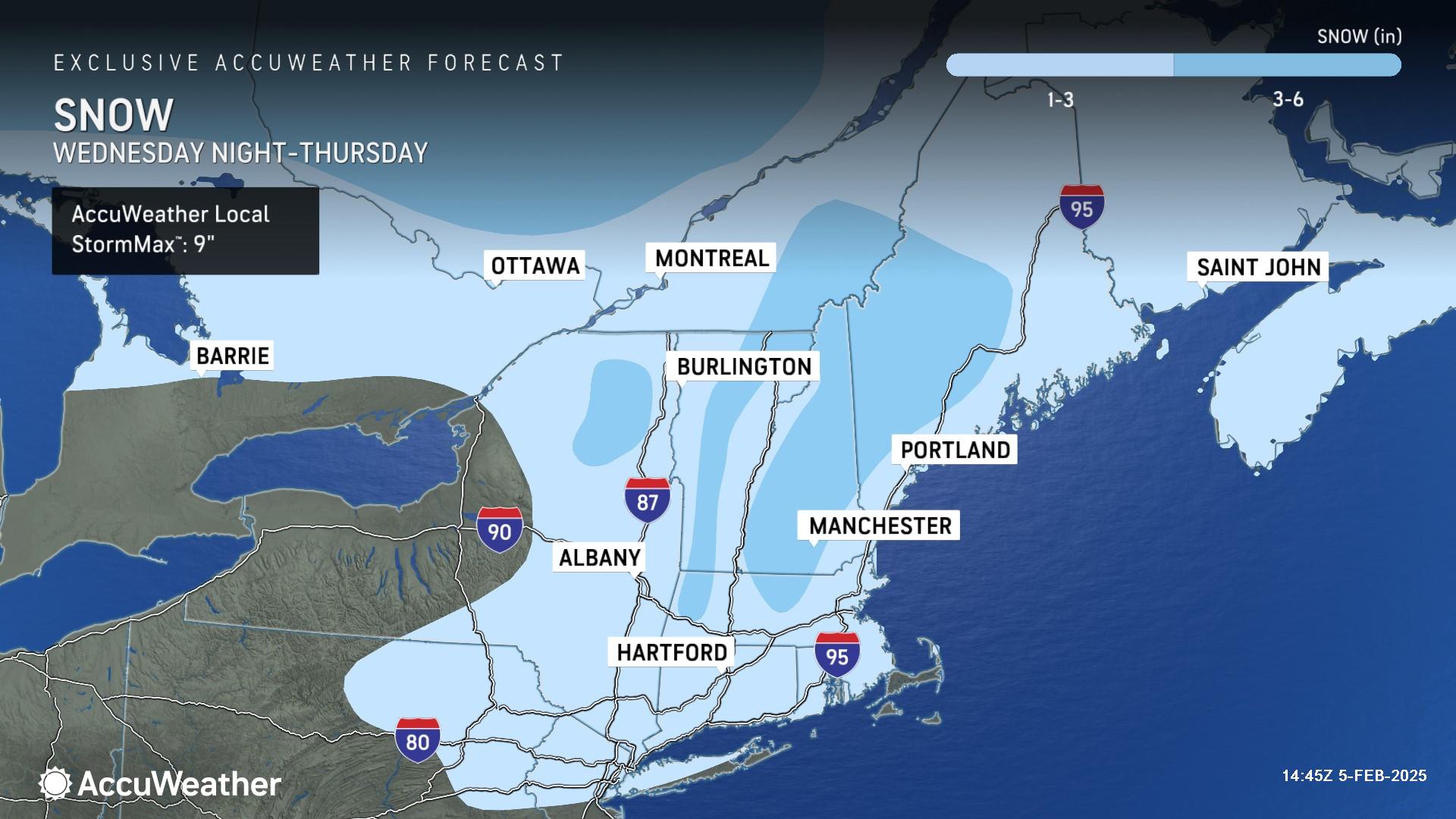
As the storm pushes eastward, a swath of accumulating snow is expected across portions of the Northeast and New England from Wednesday night into Thursday. Snow accumulations of 1-3 inches are expected across parts of northeastern Pennsylvania, northern New Jersey, New York City, and Maine, with a plowable 3-6 inches of snow expected in the higher elevations of northern New York, Vermont, New Hampshire and Maine. The AccuWeather Local StormMax™ in this region is 9 inches.

Midweek Snow — East

AccuWeather forecast map showing expected snowfall from Wednesday night into Thursday. Light blue shading covers much of the northeastern U.S. and parts of Canada, including Albany, Hartford, Manchester, Portland, Burlington, Montreal, and Ottawa, indicating snowfall accumulation. Darker blue regions suggest higher snowfall amounts, particularly in parts of Vermont and northern New York. The snowfall key at the top indicates expected amounts, ranging from 1-3 inches (light blue) to 3-6 inches (darker blue). A black text box in the top left notes that the AccuWeather Local StormMax™ could reach 9 inches. Timestamp in the bottom right reads 14:45Z, February 5, 2025.

Colder air and gusty winds could complicate storm cleanup and power restoration efforts after the storm across parts of the Great Lakes and Northeast.

AccuWeather forecast map highlighting strong winds expected from Thursday to Friday. A large area shaded in light purple covers parts of the Great Lakes region and the Northeast, including cities such as Green Bay, Grand Rapids, Detroit, Cleveland, Buffalo, Binghamton, Pittsfield, and Portland. Wind speeds of 40-50 mph are indicated in the central portion of the storm area. A dashed black line shows the expected progression of high winds from Thursday into Friday. A black text box in the top left notes that the AccuWeather Local StormMax™ could reach 65 mph. Timestamp in the bottom right reads 07:25Z, February 5, 2025.

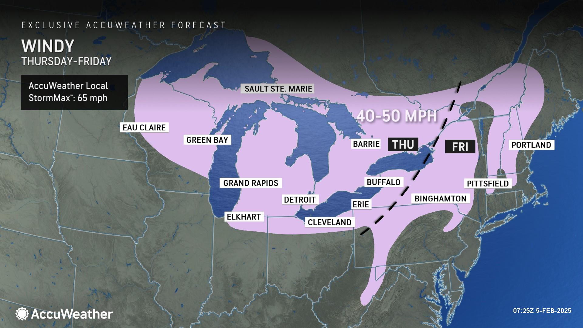
Widespread wind gusts of 40-50 mph are forecast across the Great Lakes Thursday before shifting into the interior Northeast on Friday. Wind gusts above 30 mph are possible Friday across the Interstate 95 corridor in the Northeast.

Weekend winter storm

AccuWeather forecast map highlighting an ice storm expected from Friday night through Sunday. A broad pink-shaded region stretches from Des Moines and Burlington through Chicago, Fort Wayne, Detroit, Pittsburgh, and Washington, extending eastward to New York, Kingston, and Boston. Darker pink areas indicate regions with more severe ice accumulation, particularly around parts of Pennsylvania and West Virginia. The map includes warnings for slippery travel and power outages. A color bar at the top classifies the storm’s impact from localized to severe. Timestamp in the bottom right reads 07:54Z, February 5, 2025.

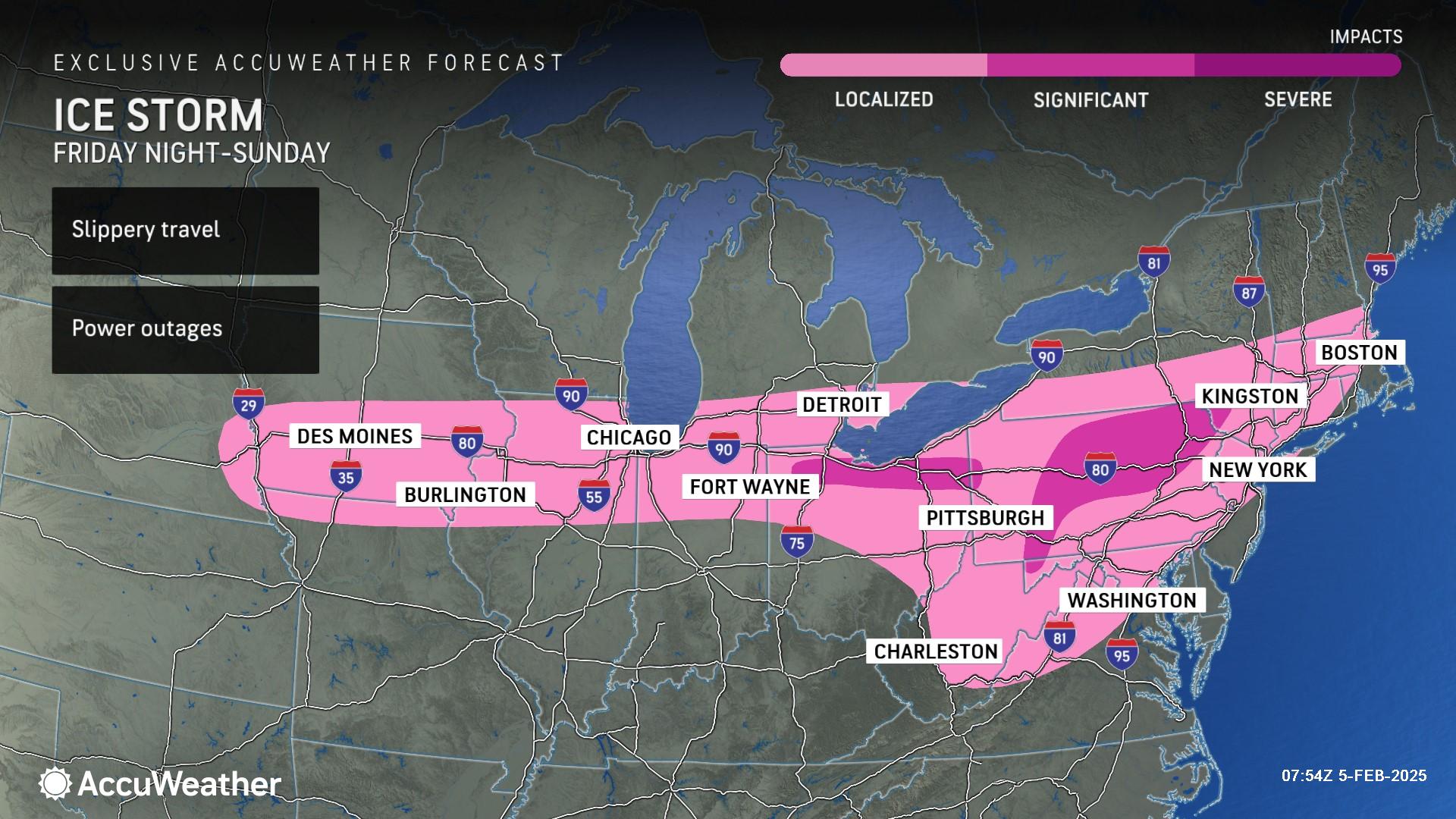
A second winter storm is expected to bring icy impacts to a 1,300-mile-long swath stretching from the Midwest to New England from Friday night through Sunday.

The most significant risk of icing lies across an area of far northern Ohio, and across parts of southwestern, central and northern Pennsylvania.

Weekend Ice Storm

AccuWeather forecast map showing expected snowfall from Friday night through Sunday. A wide band of snow extends from Bismarck, Fargo, and Sioux Falls through Minneapolis, Green Bay, Sault Ste. Marie, Detroit, Buffalo, Ottawa, Burlington, and Quebec City. The snowfall key at the top indicates expected amounts, ranging from 1-3 inches (light blue) to 3-6 inches (medium blue) and 6-12 inches (dark blue). A black text box in the top left notes that the AccuWeather Local StormMax™ could reach 18 inches. Timestamp in the bottom right reads 15:34Z, February 5, 2025.

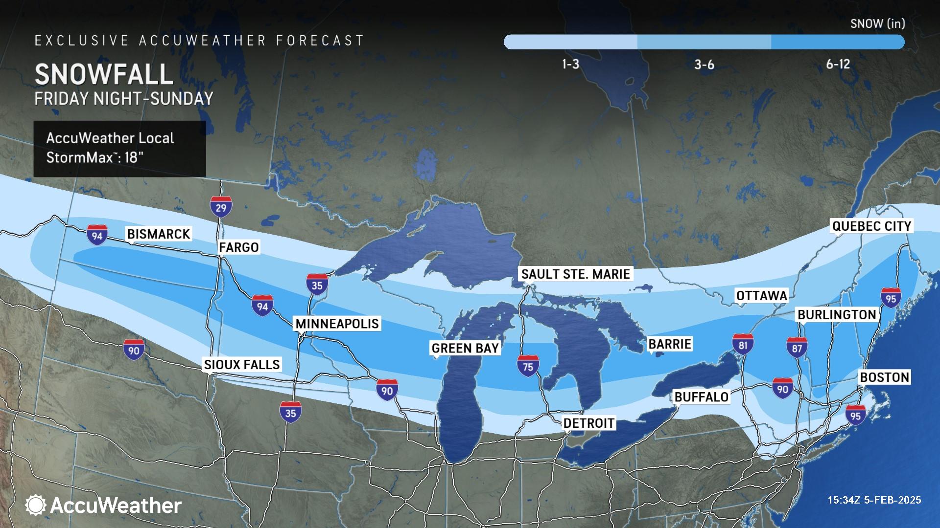
Snow accumulations of 1-3 inches are forecast across the northern Plains through the Great Lakes and into portions of the Northeast. A zone of plowable snow is expected across the Dakotas and eastward through Maine, including Minneapolis, Minnesota; Green Bay, Wisconsin; and Burlington, Vermont. The AccuWeather Local StormMax™ across the region is 18 inches.

AccuWeather forecast map highlighting power outage risks from late Friday night through Sunday morning. A broad yellow-shaded region indicating localized outage risk stretches from Des Moines, Peoria, and Chicago through Toledo, Erie, Scranton, and Springfield. A small orange region near Pittsburgh and parts of West Virginia suggests a higher risk of more widespread outages. A color bar at the top categorizes the outage risk from localized (yellow) to widespread (red). Timestamp in the bottom right reads 16:23Z, February 5, 2025.

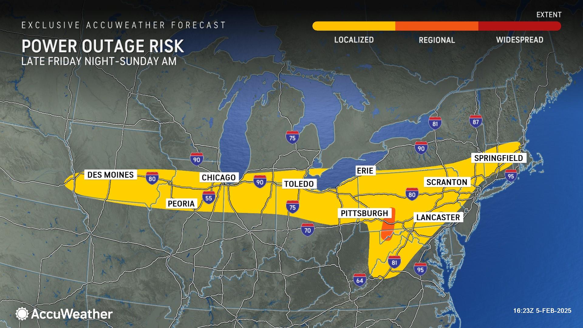
Localized power outages are possible across a zone stretching from the Midwest through the Northeast late Friday night through Sunday morning.

There is a risk of regional power outages in western Pennsylvania, western Maryland and northern West Virginia.

AccuWeather forecast map showing the potential for accumulating snow from a winter storm expected next week. A broad blue-shaded region stretches from Denver and Wichita in the west through Kansas City, St. Louis, Des Moines, Chicago, and Detroit, extending eastward through Pittsburgh, Charleston, Buffalo, New York, Burlington, and Boston. The storm's progression is indicated by dashed black lines, with expected impacts on Monday in the central U.S., Tuesday in the Midwest, and Wednesday in the Northeast. The text 'Potential for Accumulating Snow' is prominently displayed in the center of the map. Timestamp in the bottom right reads 07:25Z, February 5, 2025.

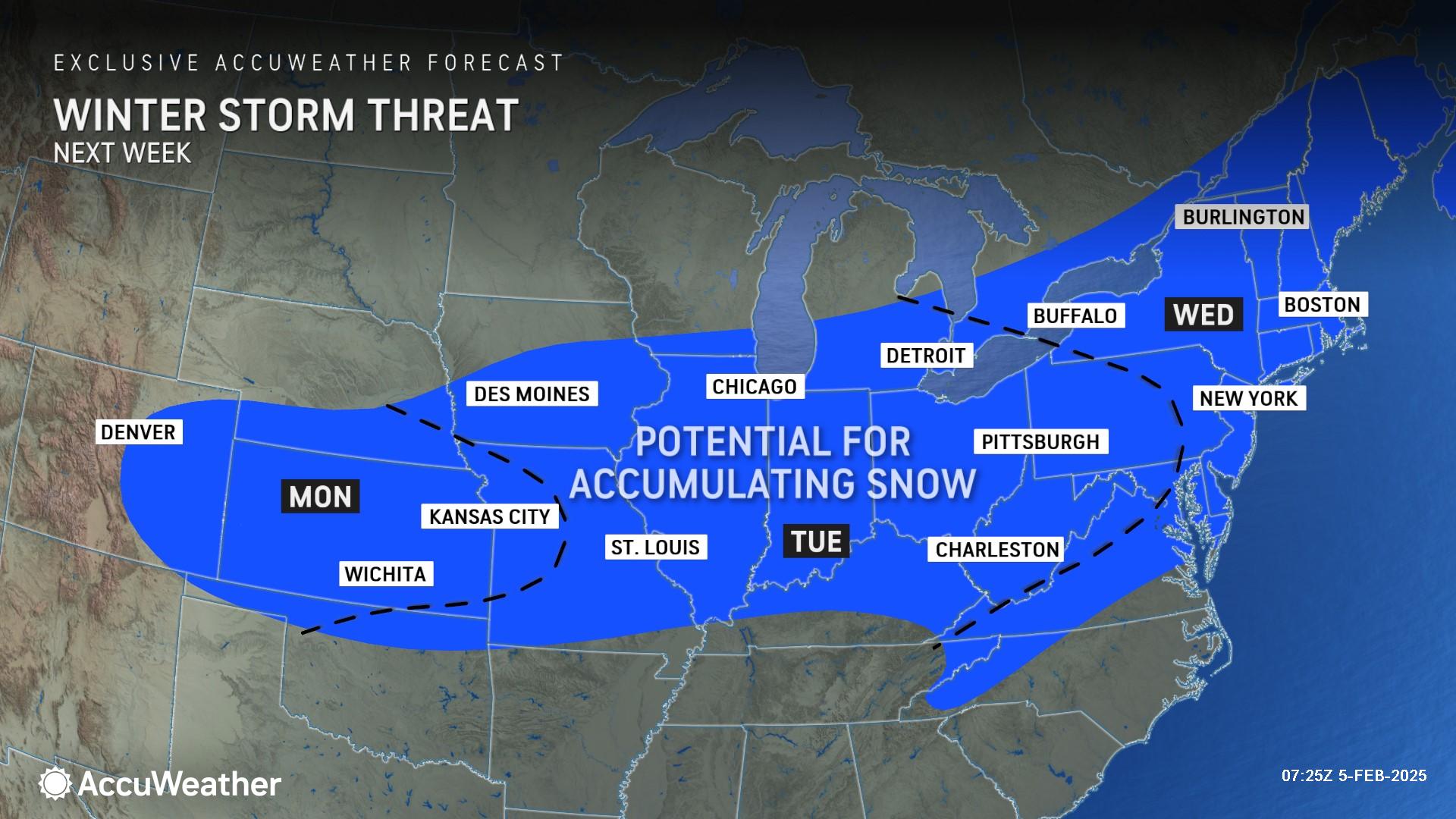
Winter storm threat next week

AccuWeather expert meteorologists say the stormy pattern will produce a third winter storm next week that could bring accumulating snowfall to parts of the Midwest, Northeast and mid-Atlantic. Check back with AccuWeather often for updates.

“Organizers and fans of both teams headed to the big game in New Orleans need to keep a close eye on next week’s winter storm,” AccuWeather Senior Meteorologist Bill Deger said. “Snow could disrupt travel plans for fans and players returning home to Philadelphia and Kansas City after the big game. Wintry weather could also impact plans for a victory parade or outdoor celebrations for the winning team.”

AccuWeather forecast map showing a stormy weather pattern expected into mid-February. A red 'L' symbol near Kansas City marks a storm system's origin, with red arrows indicating its projected track northeastward through Cleveland, Buffalo, and Burlington. The map highlights contrasting weather patterns: a blue-shaded area labeled 'Cold Shots' covering the Midwest and Northeast, including Omaha, Green Bay, and Chicago, while an orange-shaded region labeled 'Mild Waves' covers the southeastern U.S., including Atlanta, Charleston, and Jacksonville. A green area in the Gulf of Mexico labeled 'Moisture' suggests incoming warm, humid air. Timestamp in the bottom right reads 07:25Z, February 5, 2025.

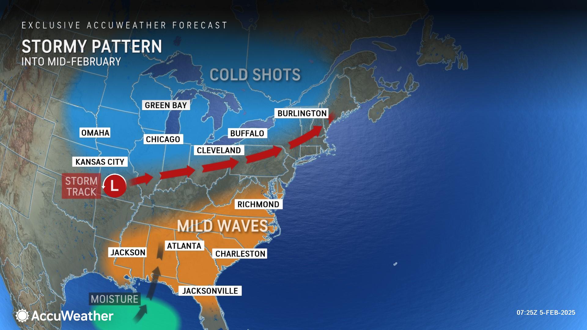
AccuWeather long-range experts say the stormy pattern bringing rounds of snow, sleet and ice to the Midwest, Northeast and mid-Atlantic is expected to last into mid-February.

submitted news

The author "submitted news" indicates that the information in the article was provided to the Greylock Glass and may have been published with little or no editorial alteration. If you have any questions or comments about this policy, please e-mail us at editor@greylockglass.com.

Leave a Reply

This site uses Akismet to reduce spam. Learn how your comment data is processed.

The Dial Radio

A vintage-style 1940s WPA-inspired travel poster promoting camping in Massachusetts. The illustration features a glowing campfire surrounded by tents and tall pine trees, set against a backdrop of rolling mountains and a crescent moon in a twilight sky. Bold, stylized typography at the bottom reads "Enjoy Camping in Massachusetts", in a classic retro travel poster design with a muted color palette of greens, oranges, and blues. The composition evokes a nostalgic, screen-printed aesthetic reminiscent of mid-century national park advertisements.
Previous Story

Massachusetts DCR announces 2025 camping season, reservations open Feb. 19

A red fox with orange-brown fur, black legs, and a white muzzle crouches inside a wire mesh cage. The fox's eyes are wide open, and its ears are perked forward. The cage has a metal grid floor and wire walls, with a dark enclosure visible in the background. The animal appears alert but confined.
Next Story

As hundreds of suffering animals are rescued from a Midwest fur factory farm, Massachusetts legislators seek to end Bay State’s support for fur farming with humane bills 

Latest from Climate