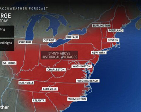
AccuWeather Global Weather Center – January 4, 2024 – We have a tale of 2 storms starting the New Year off in the United States, with severe weather impacting large sections of the country. First, a major winter storm packing travel-snarling snow and dangerous ice is on track to arrive in the Northeast this weekend, a storm that AccuWeather meteorologists say will deliver the first big snowfall along part of the Interstate 95 corridor in nearly two years.
Said AccuWeather Sr. Director of Forecasting Operations Dan DePodwin, “Locations in the Northeast that receive a half foot of snow from this weekend’s storm are unlikely to be hit with significant snow twice in one week. Instead, next week’s storm brings the risk of heavy rain and damaging winds in this area of the country. This raises the concern for flooding due to the combination of rain and snowmelt, along with power outages due to strong winds.”
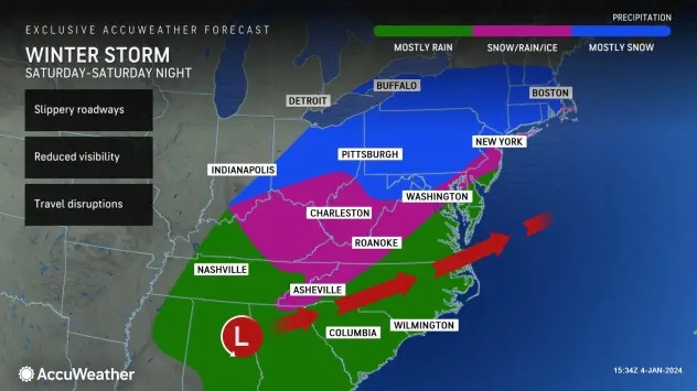
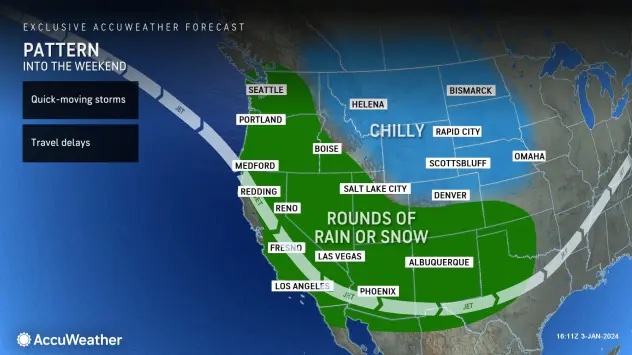
This first cross-country storm will push across the Southwest into Thursday night before swinging eastward, where it will deliver heavy rain and thunderstorms to the Gulf Coast states before evolving into the year’s first major snowstorm along the upper portion of the East Coast.
From late Thursday night to Friday night, a swath of drenching rainfall and locally gusty thunderstorms will begin to impact areas of the Gulf Coast. The persistent rainfall could bring drought relief for some, especially for parts of Louisiana and Mississippi where levels of extreme to exceptional drought have gripped the region, according to the U.S. Drought Monitor.
As the storm advances northeastward to the mid-Atlantic coast from Saturday into Sunday, it is expected to strengthen as it dumps snow and ice in a zone spanning from the central Appalachians to New England. Forecasters caution that the heaviest snow is taking aim from northeastern Pennsylvania to central and southern New England, where nearly a foot of snow may pile up.
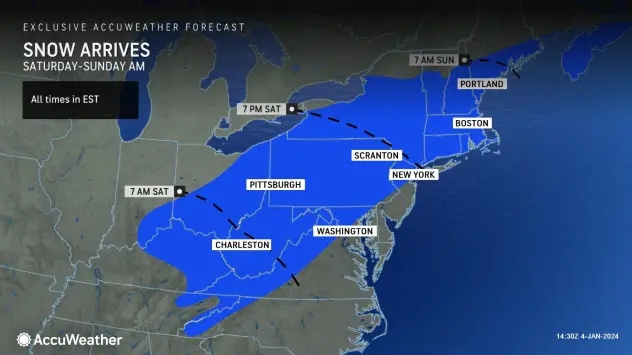
Travel conditions can rapidly deteriorate throughout Saturday and Saturday night as snow and ice spread across the region. From Saturday to Sunday, a swath where enough snow to shovel and plow is projected to fall from the Smoky Mountains to part of northern New England.
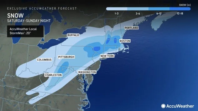
Heavy snowfall totals between 6 to 12 inches can be collected from the higher terrain in northern West Virginia, western Maryland and southwestern Pennsylvania. But as the storm gains strength and moisture from the Atlantic, it will begin to unload snow at a heavy and steady rate from northeastern Pennsylvania to the middle and lower part of the Hudson Valley to central and southern New England. 6-12 inches of snow will be common in this area, with the AccuWeather Local StormMax™ of 20 inches.
Hourly snowfall rates in this zone may exceed an inch per hour, which can overwhelm city and highway departments. Motorists on the roads during the height of the storm may be at risk for becoming stuck or stranded.
Motorists are urged to check their local forecast on AccuWeather often and stay aware of changing weather conditions before taking to the roads, especially any college students returning to campus since winter break comes to an end this week for some universities.
Snow drought likely to end in NYC
his weekend, millions across the Northeast may experience their first winter storm featuring snowfall amounts greater than 1 inch since early 2022.
A few inches of snow or more can occur along the I-95 corridor from New York City to Boston, which would be the most snow some of these cities have seen since early 2022 thanks to the multiyear drought of major snowstorms in these areas, added Porter.
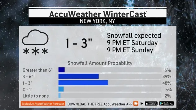
The last time a single storm delivered more than an inch of snow in New York City was on Feb. 13, 2022. Warm air from the ocean will likely play a role in New York City, with a mixing or change to rain likely at the storm’s height.
The last time there was a snowstorm that brought at least an inch of snow to Philadelphia was on Jan. 28-29, 2022. However, this may not be the storm to snap the string in Philadelphia, Baltimore and Washington, D.C., along I-95. The storm may still be struggling in strength as it passes through these areas and, combined with the warming effects of the Atlantic, could result in much more rain rather than accumulating snow.
Snowfall accumulations will ramp up as they often do north and west of I-95 in the mid-Atlantic, with a few inches for some of the northern and western suburbs. However, not too far to the north and west of New York City, the snowfall may ramp up exponentially from the strengthening storm.
Of all the major cities along I-95, Boston is in the best position to pick up 4-8 inches of snow from the storm with heavier amounts to the west of the city, where any mixing in of sleet and rain is unlikely.
Icy forecast raising concerns of power outages
As cold air is pulled southward, a mixture of snow, sleet and freezing rain can spread over parts of far eastern Tennessee and western North Carolina through eastern West Virginia and western Virginia, but the ice threat is mainly expected to be elevational dependent. Locations surrounding the Smoky Mountains to the Blue Ridge Mountains could face the greatest risk for dangerous ice buildup.
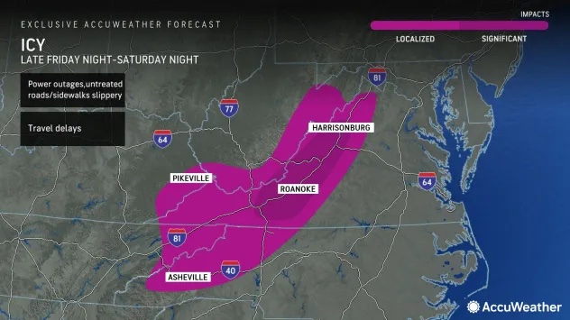
While some elevations could receive a mixture of snow and sleet, leaving untreated sidewalks and roadways slippery, others could have mainly freezing rain. The accumulation of ice poses additional risks, including the potential for tree branches to snap and weigh down power lines, leading to power outages.
“Travelers are urged to exercise extreme caution as seemingly wet roads may be coated with a hazardous layer of ice,” noted AccuWeather Meteorologist Elizabeth Danco.
Being prepared with extra batteries, fully-charged cell phones and a generator, if available, will come in handy in the case of localized or widespread power outages.
Residents across portions of the Tennessee and Ohio valleys through New England will want to dust off their snow shovels and snow blowers and ensure their vehicle tires have a healthy amount of tread on them in advance of the storm’s arrival. Additional preparations, such as getting out sidewalk salt and cinders and packing an emergency kit in their car that contains an extra hat, gloves or scarf, may be helpful.
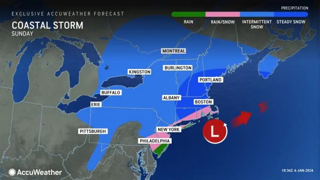
As the storm shifts northward along the New England coast by Sunday, the steadiest snow is expected to focus on areas of northern Connecticut, Massachusetts, southern New Hampshire and parts of far southern Maine. Forecasters say that a separate storm tracking north of the Great Lakes and across southern Canada can also factor into how long snow showers persist across the interior Northeast.
On the heels of the weekend nor’easter, a second major cross-country storm will threaten heavy snow along a 1,000-mile swath in the central US and may be more impactful.
AccuWeather meteorologists warn that this storm could hit travel hard in the Central states, with the major hubs of Chicago and Kansas City, Missouri, facing heavy snow and the potential for blizzard conditions.
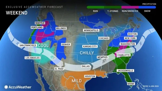
The beginnings of the major storm for the Central states early next week will stem from the West this weekend, with areas of low-elevation rain and mountain snow. Wintry precipitation may make travel difficult over the passes from the Cascades and Sierra Nevada to the southern Rockies.
With these storms hitting one area hard one day and another the next, airline passengers may face flight delays and cancellations as crews and aircraft are displaced.
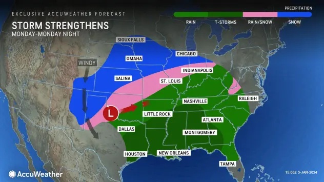
Soon after the storm emerges from the southern Rockies Sunday night, it will track northeastward over the southern Plains and the Mississippi Valley from Monday to Tuesday before exiting by way of the Great Lakes Tuesday night.
The storm will be multifaceted, with major impacts from heavy snow, heavy rain and potentially dangerous severe thunderstorms, AccuWeather Meteorologist Brandon Buckingham said.
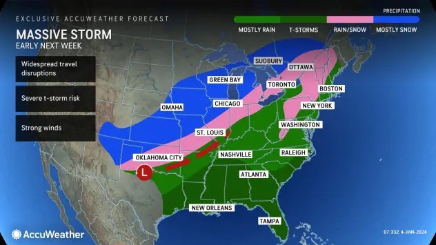
“It has the potential to be the largest storm of the winter so far for the U.S. in terms of affecting all but perhaps parts of the northern Rockies and northern High Plains,” Buckingham added. More than 40 of the lower 48 states may be affected by the storm at some point.
Long stripe of snow to unfold with blizzard conditions possible
Just to the north and west of the track of the center of the storm, accumulating snow is in store from northern New Mexico, the panhandles of Oklahoma and Texas and southeastern Colorado to central and northern Illinois, central and southern Wisconsin and central and northern Michigan.
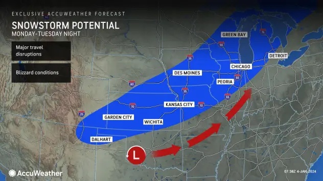
Snowfall will cause wintry trouble in the major cities of Chicago; Des Moines, Iowa; Milwaukee; Kansas City, Missouri; and Wichita, Kansas. Motorists on many major highways in the region – including Interstates 35, 55, 70, 80 and 90 – could face treacherous travel as a result of the snow
“The exact track of the storm will determine which areas pick up several inches to perhaps a foot of snow,” Buckingham explained. “How quickly the storm strengthens will determine how fast strong winds ramp up over portions of the Plains and the Upper Midwest. Blizzard conditions may develop should the storm evolve to its full potential.”
Storm’s warm side to pack drought-quenching rain, flooding risk
As the storm tracks over the Central states, it will pull warm, moist air northward over the lower Mississippi Valley and Southeast states unleashing areas of drenching rain and thunderstorms.
The heavy rain will be a double-edged sword with much-needed moisture for drought-stricken areas. Enough rain may fall on the middle portion of the Mississippi River and the Ohio River to temporarily raise water levels.
“However, too much rain may pour down and lead to flash, urban and small stream flooding,” Buckingham said. “In parts of the Southeast, the runoff from this storm and moist ground left behind from prior storms in December may lead to new rises and flooding on some area rivers.”
The same applies to parts of the Northeast, where rainstorms have left the ground very moist and rivers running high. Since the storm early next week is likely warmer than this weekend’s snow and wintry mix, runoff could be excessive and lead to flooding along streams and rivers, Buckingham explained.
Stubborn pockets of cold air may lead to areas of ice and a heavy wintry mix across the interior Northeast with the new storm.
“Just as the storm may produce strong winds in parts of the Heartland, it may also bring strong and potentially damaging winds in the vicinity of the central Appalachians by Tuesday,” AccuWeather Senior Meteorologist Bob Smerbeck said.
Tornadoes could accompany Southern severe thunderstorms
The storm may bring the most significant risk of severe weather in weeks to parts of the lower Mississippi Valley and Southeast states.
“The storm’s main threats will stem from torrential downpours and powerful wind gusts of 55-66 mph with an AccuWeather Local StormMax™ of 70 mph. But, there is the potential for a few tornadoes to be spawned from the strongest thunderstorms early next week as well,” Buckingham said.
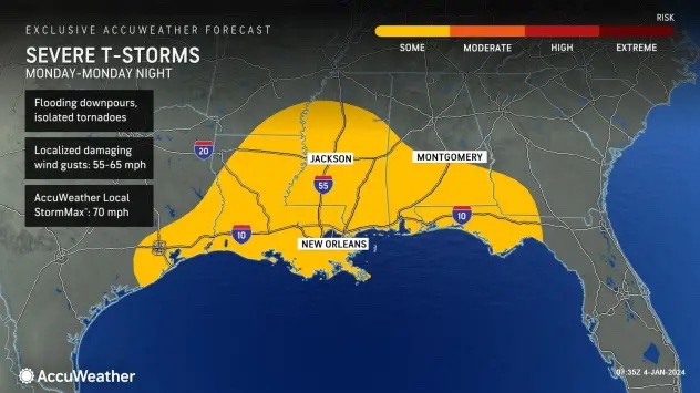
The greatest risk of severe weather from Monday to Monday night will stretch along portions of I-10, I-20 and I-55 over the South-Central states and includes the major cities of Mobile, Alabama, Houston and New Orleans.
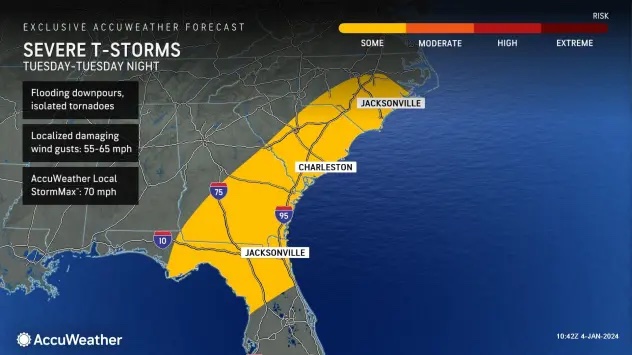
On Tuesday, the severe weather threat will extend from the northeastern Gulf coast to coastal areas of the Carolinas, with the cities of Jacksonville, Florida; Savannah, Georgia; and Charleston, South Carolina, potentially in the path of intense thunderstorms.
More storms packing snow, rain and severe weather will likely follow for the Central states as the month progresses. As Arctic air invades the Rockies and Plains, warmth may surge in the East. The extreme temperature contrast could make some storms even more dynamic and disruptive.
Additional AccuWeather Resources: